Let’s Grow: Streetcars and Your Neighborhood
A frequently asked question about the Cincinnati streetcar is, “When is it coming to my neighborhood?”
Currently, the City of Cincinnati is focused on building the current 3.6 mile loop around the Central Business District and Over-The-Rhine, where the most employers and revenue-generating entertainment is located. The next phase of the streetcar is expected to travel north on Vine Street to Uptown, Corryville, and Clifton.
But then where will it go?
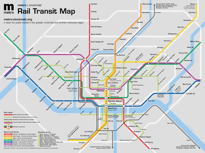
It’s hard to say, as the City of Cincinnati is only 30% into its research on planning the Uptown phase. In the meantime, a University of Cincinnati student earning his Masters of Architecture outlined a longer streetcar route for an academic project. The design for this theoretical streetcar route is based on the current streetcar route, the 2002 Metro Moves light rail initiative developed by the Southwest Ohio Regional Transit Authority, and the 2030 Regional Transportation Plan unanimously adopted in 2008 by the OKI Regional Council of Governments.
The light green route represents the streetcar line, and its possibility to expand outward to such neighborhoods as Westwood, Price Hill, and Camp Washington on the west side, northward to Avondale and Northside, and encompass Walnut Hills, Oakley, and Columbia-Tusculum on the east side. The academic project, entitled Metro|Cincinnati, also includes route projections for commuter rail, heavy rail (such as a subway), and extensions into Northern Kentucky.
While it will be up to the city to chart the course of the streetcar to its next neighborhood, it’s likely that it will be one or more of the communities highlighted on the Metro|Cincinnati map.
